Wednesday, June 25, 2008
San Pablo City High Res in Google Earth... Kind Of
If you haven't had the chance to download Google's fantastic free program "Google Earth", please do so here.
Basically, Google Earth is a virtual world globe on your computer. Google Earth is so detailed that you can zoom in into cities anywhere in the world and see the streets, the buildings, the vehicles, landmarks, and so on.
Not every part of the world can be seen in high resolution though, and for the longest time, San Pablo City can only been seen as a low res image... until recently. Kind of.
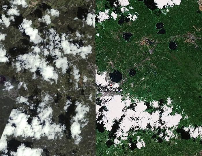
Below is how San Pablo looks on Google Earth now:

You will notice that the image is split in the middle with a definite line. The left section in dull green-grey and the right section in bright green. This means that you can zoom in on the left section and see more detailed images.
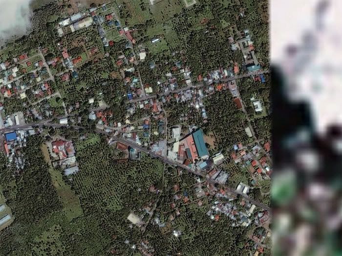
Zooming in you can see streets, houses, trees, etc.

In this zoom you can see the National Highway and the San Pablo diversion road. You can also see the Caltex gas station, San Pablo City Medical Center, the post office in San Roque, etc. This sattelite photo is from 2001 so new structures, like the Chowking and the new 7-11 are not there yet.
Hopefully, Google Earth will finally show San Pablo entirely in high resolution, and update their photos with more recent ones.
Basically, Google Earth is a virtual world globe on your computer. Google Earth is so detailed that you can zoom in into cities anywhere in the world and see the streets, the buildings, the vehicles, landmarks, and so on.
Not every part of the world can be seen in high resolution though, and for the longest time, San Pablo City can only been seen as a low res image... until recently. Kind of.
Below is how San Pablo looks on Google Earth now:

You will notice that the image is split in the middle with a definite line. The left section in dull green-grey and the right section in bright green. This means that you can zoom in on the left section and see more detailed images.
Zooming in you can see streets, houses, trees, etc.

In this zoom you can see the National Highway and the San Pablo diversion road. You can also see the Caltex gas station, San Pablo City Medical Center, the post office in San Roque, etc. This sattelite photo is from 2001 so new structures, like the Chowking and the new 7-11 are not there yet.
Hopefully, Google Earth will finally show San Pablo entirely in high resolution, and update their photos with more recent ones.
Tuesday, June 24, 2008
Typhoon Frank Hits San Pablo
Typhoon Frank (international name FENGSHEN) hit San Pablo on the early morning of June 22, 2008. Thankfully, it didn't do much damage, at least in the neighborhood where I am at, except to down a few trees and knock out electricity for a day. I heard of some other areas in San Pablo that still has no electricity. But I hear of no grim news, the same kind of news that has befallen our fellow countrymen elsewhere, like in Iloilo. We here in San Pablo got lucky, this time.
I made a video blog about it at You Tube, which has gotten a lot of views. I guess it would be understandable because a lot of people outside of the Philippines, specially Filipinos and those who are involved with Filipinos in some way or the other, would be very concerned.
[vlog] Typhoon Frank, June 22, 2008
http://www.youtube.com/watch?v=EVQl10KmEHI
I wish I could have gotten some footage of the typhoon itself at its height, but it was in the middle of the night and it was just too dark.
Here are the honors that I got for the video today...
Honors for this video (8)
#95 - Most Discussed (Today) - People & Blogs
#81 - Most Viewed (Today) - People & Blogs - Australia
#46 - Most Viewed (Today) - People & Blogs - Canada
#78 - Most Viewed (Today) - People & Blogs - United Kingdom
#34 - Most Viewed (Today) - People & Blogs - Ireland
#55 - Most Viewed (Today) - People & Blogs - New Zealand
#53 - Most Viewed (Today) - People & Blogs
#14 - Most Viewed (Today) - People & Blogs - South Korea

