Wednesday, June 25, 2008
San Pablo City High Res in Google Earth... Kind Of
If you haven't had the chance to download Google's fantastic free program "Google Earth", please do so here.
Basically, Google Earth is a virtual world globe on your computer. Google Earth is so detailed that you can zoom in into cities anywhere in the world and see the streets, the buildings, the vehicles, landmarks, and so on.
Not every part of the world can be seen in high resolution though, and for the longest time, San Pablo City can only been seen as a low res image... until recently. Kind of.
Below is how San Pablo looks on Google Earth now:
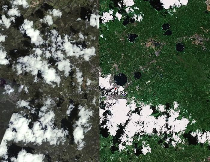
You will notice that the image is split in the middle with a definite line. The left section in dull green-grey and the right section in bright green. This means that you can zoom in on the left section and see more detailed images.
Zooming in you can see streets, houses, trees, etc.
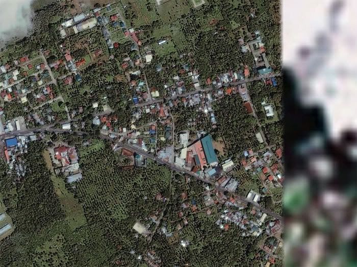
In this zoom you can see the National Highway and the San Pablo diversion road. You can also see the Caltex gas station, San Pablo City Medical Center, the post office in San Roque, etc. This sattelite photo is from 2001 so new structures, like the Chowking and the new 7-11 are not there yet.
Hopefully, Google Earth will finally show San Pablo entirely in high resolution, and update their photos with more recent ones.
Basically, Google Earth is a virtual world globe on your computer. Google Earth is so detailed that you can zoom in into cities anywhere in the world and see the streets, the buildings, the vehicles, landmarks, and so on.
Not every part of the world can be seen in high resolution though, and for the longest time, San Pablo City can only been seen as a low res image... until recently. Kind of.
Below is how San Pablo looks on Google Earth now:
You will notice that the image is split in the middle with a definite line. The left section in dull green-grey and the right section in bright green. This means that you can zoom in on the left section and see more detailed images.
Zooming in you can see streets, houses, trees, etc.
In this zoom you can see the National Highway and the San Pablo diversion road. You can also see the Caltex gas station, San Pablo City Medical Center, the post office in San Roque, etc. This sattelite photo is from 2001 so new structures, like the Chowking and the new 7-11 are not there yet.
Hopefully, Google Earth will finally show San Pablo entirely in high resolution, and update their photos with more recent ones.
# posted by Gerry Alanguilan @ 9:13 PM 
Comments:
<< Home

Hi! My name is Tricia Torres and I'm a senior student in the Ateneo de Manila University. For my thesis, i'm working on a tourism campaign for San Pablo city by making a brochure-booklet, a website similar to this one, and a video. I was wondering if I could use some of your content, with your permission of course? If you would like to contact me, my email address is thehobbit15@yahoo.com. Hoping to hear from you soon, thank you very much :)
Post a Comment
<< Home
![]()